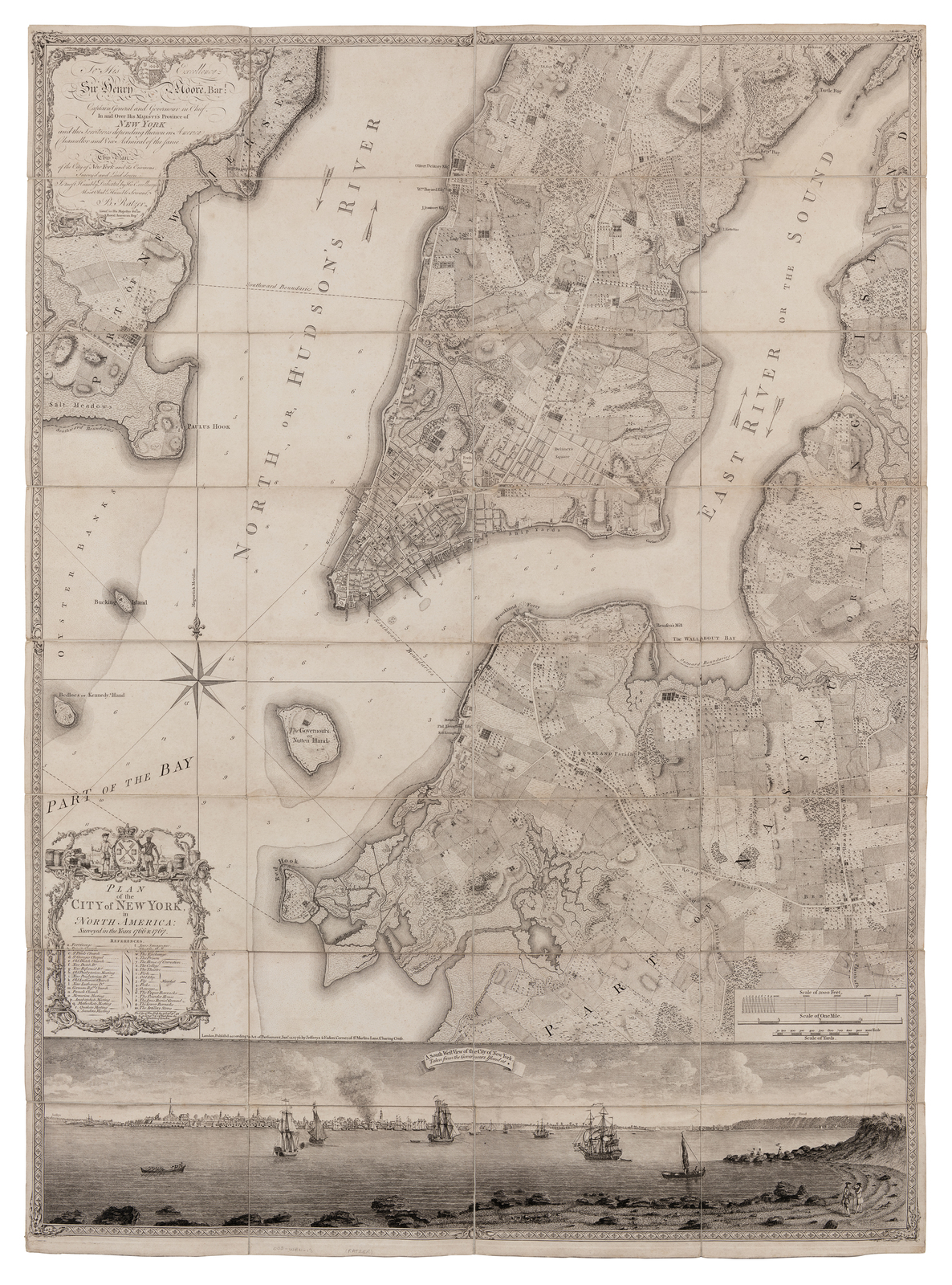
RATZER, Bernard (fl. 1756-1777). Plan of the City of New York in North America, surveyed in the years 1766 & 1767. London: Jefferys and Faden, “Jan.y” 12, 1776.
Sale 697 - Fine Books and Manuscripts including Americana
Nov 6, 2019
10:00AM CT
Live / Chicago
Estimate
$80,000 -
$120,000
Sold for $162,500
Sold prices are inclusive of Buyer’s Premium
Lot Description
RATZER, Bernard (fl. 1756-1777). Plan of the City of New York in North America, surveyed in the years 1766 & 1767. London: Jefferys and Faden, “Jan.y” 12, 1776.
Copper-engraved plan of New York on four sheets, joined. Overall sheet 48 ½ x 35 ½ in (1235 x 900 mm), deckle edges. With engraved panoramic view of New York below map after a painting by Robert Davies at bottom. (Dissected into 16 sections, with later linen backing; some minor curling at seam edges). Float-mounted and framed.
"PERHAPS THE FINEST MAP OF AN AMERICAN CITY and its environs produced in the eighteenth century" (Augustyn).
Second issue (after the ca 1770 issue known in three copies). The Ratzer map is a cartographic masterpiece, the finest map of any American city produced in the 18th century, and is one of the most important iconographic symbols of the city of New York. Its artistic virtuosity and unrivaled accuracy define it as the apogee of a sequence of great maps of the city produced just before and during the Revolutionary War with a sharpness and sensitivity of draftsmanship that makes it stand alone from any other American maps of this period.
Ratzer's map developed from surveys of 1766 and 1767, the first engraved form was his "Ratzen" plan of the city itself published in 1769, engraved by Kitchen. By ca 1770 the larger plan of the city and its environs had been finished and was published undated by Thomas Kitchin. The elaborate survey showing the southern end of Manhattan island, (as far north as 50th Street today), the marshy New Jersey shores of the Hudson, Kennedy, Bucking and Governors Islands, and parts of present-day Brooklyn along the East River. Title set on lower left corner of map with decorative cartouche and list of references, one compass rose, inset scale bar, and dedication to Sir Henry Moore, Governor of New York. The map surmounting an engraved panoramic view of the city from Governors island, after a 1760 view by Captain Davies.
The Ratzer map was first published in London by Thomas Kitchin ca 1770, but only two copies of this first issue survive today. The present copy, the second issue, was published by Jefferys and Faden, and although they were commercial publishers, it was rarely included in Faden's North American Atlas of 1777. Bernard Ratzer served in the British Army in the 60th or American regiment. His earliest known map is a manuscript chart of Passamquoddy Bay in Maine in 1756. Various other manuscript plans of forts followed, and he collaborated with Sauthier on his survey of New York, published in 1776. In 1769 Sir Henry Moore gave him the task of surveying the New York New Jersey border. Despite the commercial nature of Faden and Jefferys, this New York plan had a limited circulation and certainly very few copies are seen on the market today. It ranks as one of the most attractive of all maps, one of the high points of the art of the military map maker. Cohen & Augustyn, Manhattan in Maps, pp.73-77; Schwartz & Ehrenberg, The Mapping of America, p. 192; Stokes, Iconography ("one of the most beautiful, important and accurate plans of New York."), p. 341.
Condition Report
The physical condition of lots in our auctions can vary due to
age, normal wear and tear, previous damage, and
restoration/repair. All lots are sold "AS IS," in the condition
they are in at the time of the auction, and we and the seller make
no representation or warranty and assume no liability of any kind
as to a lot's condition. Any reference to condition in a catalogue
description or a condition report shall not amount to a full
accounting of condition. Condition reports prepared by Hindman
staff are provided as a convenience and may be requested from the
Department prior to bidding.
The absence of a posted condition report on the Hindman website or
in our catalogues should not be interpreted as commentary on an
item's condition. Prospective buyers are responsible for
inspecting a lot or sending their agent or conservator to inspect
the lot on their behalf, and for ensuring that they have
requested, received and understood any condition report provided
by Hindman.
Please email conditionreports@hindmanauctions.com for any additional information or questions you may have regarding this lot.