[MAP]. TODESCHI, Pietro. [Nova et Acurata Totius Americae Tabula auct. G.I. Blaeu] America quarta pars orbis quam plerunq...1673. RARE.
Sale 1336 - Fine Books and Manuscripts, including Worlds of Tomorrow, and Americana
Jun 7, 2024
9:00AM CT
Live / Chicago
Own a similar item?
Estimate
$10,000 -
15,000
Price Realized
$16,510
Sold prices are inclusive of Buyer’s Premium
Lot Description
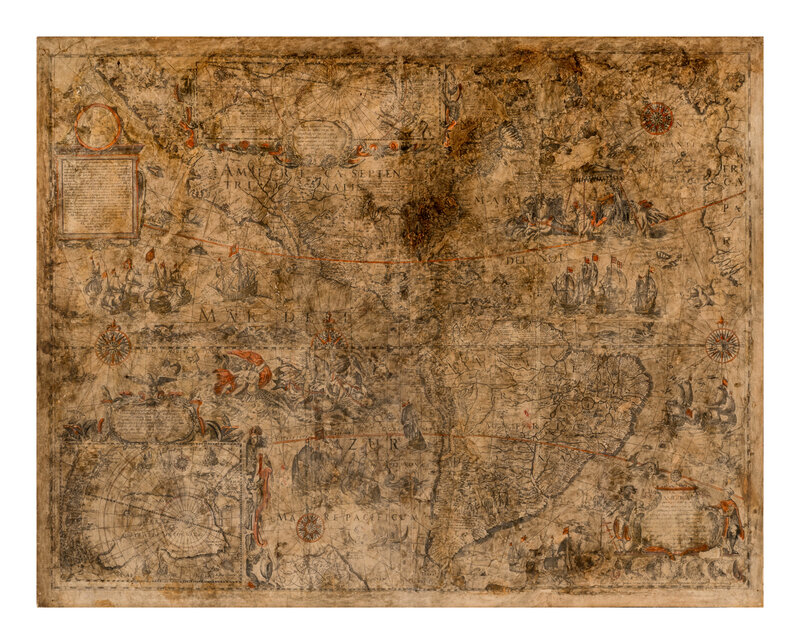
[MAP]. TODESCHI, Pietro. [Nova et Acurata Totius Americae Tabula auct. G.I. Blaeu] America quarta pars orbis quam plerunq, nuvum orbem appellitant primo detecta est anno 1492 a Christophoro Columbo... Bologna, 1673.
Hand-colored engraved wall map on 4 joined sheets laid on old (original?) linen, as issued. Overall sheet 870 x 1105 mm, mounted to board. (Trimmed to graticulated borders, areas with loss restored in facsimile, varnished, toning).
THE LAST OF THE KNOWN PUBLISHED DERIVATIVES OF BLAEU'S GREAT WALL MAP OF AMERICA. In 1608, Willem Janszoon Blaeu (1571-1638) produced "one of the most influential maps of America ever made" (Burden) that would make up a set of four large wall maps comprising of Europe, Asia, Africa, and the Americas. It is true that very few copies of Blaeu's original wall map survive today (4 complete examples are known) but despite its rarity, the influence of this map was considerable, leading to the production of several derivative maps like the present map. Burden notes that one of the notable deviations in this map is Todeschi's attempt to correlate the map with the California as an island theory by creating an island out of Baja California.
"Another Italian imitation of Blaeu's wall maps of the four continents was engraved by Pietro Todeschi in Bologna at the beginning of the 1670s; the set was published in 1673, probably by Giuseppe Longhi. Todeschi is no stranger, since he had made the large wall map of Italy (1675) by Matthaeus Greuter as well as a large town view of Bologna (1678). Because Longhi published the map of Italy, he may also have published the four maps of the continents. This set of maps closely resembles the previously discussed Venetian edition which was probably used as a model. The copyist imitated his models very accurately in the map image, the representation of the thousands of toponyms, the decorations on the map and the decorative borders...the maps are often in very poor condition" (Schilder, Monumenta Cartographica Neerlandica V, p. 195).
RARE: According to the combined census of Burden and Schilder, only 11 examples are known of this map. Burden II:433.
Condition Report
Auction Specialist