


American Travel, Exploration & Expansion
JOUTEL, Henri. Journal historique. Paris, 1713.
JOUTEL, Henri. Journal historique. Paris, 1713.
Sale 2112 - Visions of America: The Stephen White Collection
Oct 24, 2024
10:00AM ET
Live / Cincinnati
Estimate
$5,000 -
7,000
Lot Description
American Travel, Exploration & Expansion
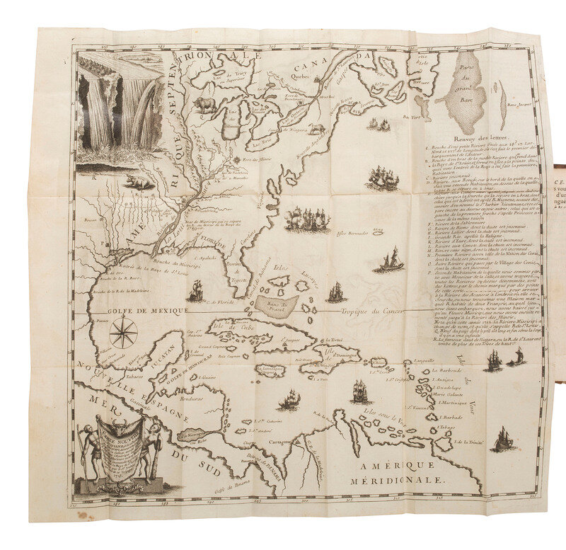
JOUTEL, Henri (ca 1640-1735). Journal historique du dernier voyage que feu M. de la Sale fit dans le Golfe de Mexique, pour trouver l'embouchure, & le cours de la Riviere de Missicipi, nommee a present la Riviere de Saint Louis, qui traverse la Louisiane. Paris: Estienne Robinot, 1713.
JOUTEL, Henri (ca 1640-1735). Journal historique du dernier voyage que feu M. de la Sale fit dans le Golfe de Mexique, pour trouver l'embouchure, & le cours de la Riviere de Missicipi, nommee a present la Riviere de Saint Louis, qui traverse la Louisiane. Paris: Estienne Robinot, 1713.
12mo (165 x 89 mm). Engraved folding map (two small sellotape repairs near stub). Contemporary French calf, spine in 6 compartments with 5 raised bands, dark red morocco lettering-piece gilt, others gilt tooled, marbled edges (some wear to joints, hinges tightened, few small stains to covers). Provenance: early marginalia throughout including on title-page.
FIRST EDITION, including the earliest map depicting the outcomes of La Salle's final two voyages. In 1682, René-Robert Cavelier, Sieur de La Salle, claimed the entire Mississippi delta for France, naming it "La Louisiane." After being appointed Governor of Louisiana, he set out from France in 1684 to establish a settlement. However, his ships missed the mouth of the Mississippi and were blown off course to present-day Texas, where La Salle was eventually murdered by his own men. Joutel, one of the few survivors of La Salle's Texas expeditions, provides the only eye-witness account of these events. His map is also regarded as the first accurate depiction of the Mississippi River. "Joutel accompanied the expedition and after La Salle's assassination he made his way across Texas to the Red River and thence to the Arkansas and up the Mississippi to Fort St. Louis. The map and the account are important documents of the East Texas region..." (Streeter). Alden & Landis 713/103; Church 855; Howes J-266 ("Most reliable eye-witness account of La Salle's two-years wanderings in Texas. The map, based on La Salle's Mississippi exploration, was the first accurate delineation of that river"); Palau 132335; Sabin 36760; Wagner Spanish Southwest 79.
This lot is located in Cincinnati.
Condition Report
Auction Specialist