Lot 222
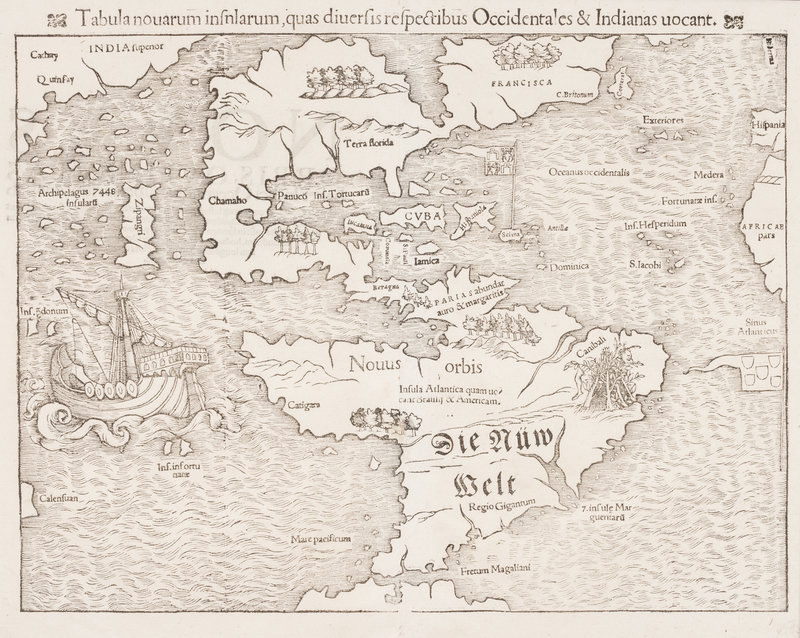
MÜNSTER, Sebastian (1489-1552). Tabula novarum insnlarum[sic], quas diversis respectibus Occidentales & Indianas vocant. Basel, 1554.
Sale 945 - Fine Printed Books & Manuscripts, Including Americana
Lots 1-307
Nov 9, 2021
4:00AM CT
Lots 308-687
Nov 10, 2021
4:00AM CT
Live / Chicago
Own a similar item?
Estimate
$4,000 -
6,000
Price Realized
$5,625
Sold prices are inclusive of Buyer’s Premium
Lot Description
MÜNSTER, Sebastian (1489-1552). Tabula novarum insnlarum[sic], quas diversis respectibus Occidentales & Indianas vocant. Basel, 1554.
Woodcut map of North and South America, 312 x 409 mm. (A few tiny holes.) Burden State 7 with Latin text on verso, without the word "ova" before "Insula Atlantica quam..." in South America, and lacking Temistitian.
Published in both Ptolemy's Geographia and Münster's own Cosmographia (as the present copy). The present copy of the map is from the 1555 Latin edition of Cosmographia, with the phrase "Insula Atlantica quam uo-/ cant Brasilii & Americam" in South America, Temistitan not named in Mexico, "ORBIS, QVI INSVLAS" the second line on the verso.
First issued in 1540, Münster's map is the earliest map to depict all of the Americas, and the first to name the Pacific Ocean ("Mare Pacificum"). The ship is Magellans' Victoria, the only vessel of five to survive his voyage. Münster relied on Verrazano's accounts of the New World and on Marco Polo's accounts of eastern Asia when producing his map. Burden 12.
Property from the Collection of Dr. Brant Mittler
Condition Report
Contact Information
Auction Specialist

