Condition Report
Contact Information
Auction Specialist
Lot 47
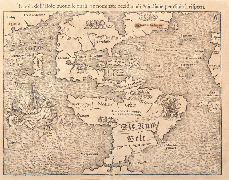
(Munster, Sebastian). Tavola dell'isole nuoue, le quali son nominate occidentali, & indiane per diversi rispetti
Sale 6308 - Printed and Manuscript Americana
Jan 29, 2025
10:00AM ET
Live / Philadelphia
Own a similar item?
Estimate
$1,200 -
1,800
Price Realized
$2,560
Sold prices are inclusive of Buyer’s Premium
Lot Description
(Munster, Sebastian). Tavola dell'isole nuoue, le quali son nominate occidentali, & indiane per diversi rispetti
(Basel, ca. 1558 or later). 8th state. Uncolored woodcut map, 11 3/4 x 17 1/4 in. (298 x 438 mm). Italian text on verso. Creasing from old fold at center, light offsetting to same; ink stain at top right over Francisca, with some loss from oxidation; window mounted to mat with duct tape, stained where mounted; archival repair at center fold on verso. Burden 12
German cartographer Sebastian Munster's (1488-1552) landmark map of North and South America, the earliest to show both continents, and to name the Pacific Ocean (mare Pacificum).
First printed in 1540 for his edition of Ptolemy's Geography, this map was included in Munster's 1544 edition of Cosmography, and "...sealed the fate of 'America' as the name for the New World..." (Burden)
Notable points include the Portuguese flag positioned over the South Atlantic, and the Spanish flag over the Caribbean. The sole surviving ship of Magellan's expedition, the Victoria, is shown in the south Pacific, while the island of Japan ("Zipangri") is shown, appearing three years before its earliest known contact with Europeans.
This lot is located in Philadelphia.

