Condition Report
Contact Information
Lot 67
PALMATARY, J[ames] T.
Sale 503 - Fine Books and Manuscripts
Sep 13, 2017
9:59AM
Live / 1338 West Lake Street
Own a similar item?
Estimate
$20,000 -
30,000
Price Realized
$200,000
Sold prices are inclusive of Buyer’s Premium
Lot Description
PALMATARY, J[ames] T.
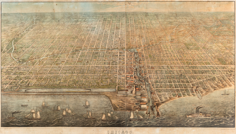
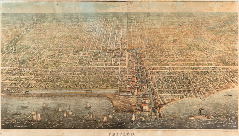
Chicago. Chicago: Braunhold & Sonne [now Charles Sonne], 1857.Engraved bird's-eye view of Chicago with contemporary hand-coloring on 4 sheets, image 1175 x 2050 mm. (Some light fraying at margins, a few areas with light cracking or chipping with occasional losses infilled, some minor browning or spotting.)FIRST EDITION. A FINE COPY OF THIS RARE AND IMPORTANT MAP.Palmatary drew his bird's-eye view of Chicago just one year after the Illinois Central Railroad was completed; when it opened in 1856, the Illinois Central was the longest railroad in the world, running 705 miles from Cairo, Illinois to Chicago, and it features prominently in Palmatary's view in the lower left, with tracks on trestles protected by breakwaters and dikes over a strip of land several hundred feet out in Lake Michigan. The Illinois Central originally intended to enter Chicago from the south, and requested permission to lay track along the lakefront to reach the city's inner harbor. They were not granted permission, however, because the section of lakefront (also visible lower left) had been designated for public use in 1836 by the Illinois and Michigan Canal Commission (marked "Public Ground-A Common to remain Forever Open, Clear, Free of Any Buildings, or Other Obstruction Whatever" on a real estate map from 1836). After months of fighting, the City Council granted the Illinois Central the land in Lake Michigan, which led to the northern terminus for the railroad in the old Fort Dearborn reservation. Visible in the lower right is an area called "The Sands," near present-day Streeterville, notorious in its time for having a high concentration of brothels, gambling dens, saloons and inexpensive motels; the Sands became a point of refuge for Chicagoans in 1871 during the Great Chicago Fire. The lower margin includes a legend of notable places in the city, including Richmond House, the U.S. Marine Hospital, Grain and Freight Houses, the McCormick Reaper Factory, the "Illi. & Diversy" Brewery, and the Chicago Water Works. The view includes street names, homes, churches, and points of industrial interest, and was lithographed by Christian Inger, or Herline & Hensel in Philadelphia. VERY SCARCE: We do not trace any other copy of this exceedingly rare map at auction in the last 100 years; it is one of four known copies, and the only known obtainable copy.Robert Holland, Chicago in Maps 1612-2002, (2005), pp.80-83; Robert Karrow, Checklist of Printed Maps of the Middle West to 1900, (1981), 4 0357; John R. Hbert and Patrick E. Dempsey, Panoramic Maps of Cities in the United States and Canada, (1984), p.38, Illinois No.146.


